What does a Global Address Framework look like?
Anthony Beck - Address Day - 2015-03-05
What does a Global Address Framework look like?
Unless states otherwise all content is under a CC-BY licence


You can access this presentation on github:
Addresses
are part of everyday life


Economy and commerce
Governance

- Without an address, it is harder for individuals to register as legal residents.
- They are not citizens and are excluded from:
- public services
- formal institutions.
- This impacts on democracy.
Urban Development

- Key to managing the explosion of rural to urban migration.
- Informal settlements housing the urban poor.
- Poor infrastructure services.
Legal and Social integration

- Formal versus Informal
- Barring individuals and businesses from systems:
- financial
- legal
- government
- ....
Security

- Addresses provide spatial structure.
- This helps to identify, locate and access marginalized areas.
Sustainability and risk management

- Addresses, geodemographics and spatial infrastructure support
- sustainability
- resilience
- disaster management
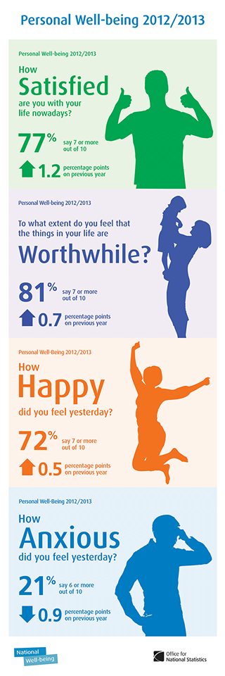
Global Wellbeing
are a jolly good thing

The address disenfranchised?
It is almost impossible for individuals to be part of society without a legal identity.
4 billion people are excluded from the rule of law because they do not have a legal identity, and that establishing such an identity often depends on having an official address.
Addresses appear to be a key element in aiding the delivery of policies at national and international levels ....
UPU (2012) p. 6
... particularly with regard to:
- governance
- rule of law
- poverty reduction
- disease prevention
- the provision of basic services such as:
- electricity
- sanitation
- water.
UPU (2012) p. 6
In Africa

This century is witnessing a fundamental change in our way of life; for the first time in history, half of the world’s population lives in towns and cities.
Urban areas are growing faster in developing countries, mostly through informal settlements.
The lack of an address, particularly in informal settlements, can also mean the lack of legal identity, equal opportunities for employment and social integration.
UPU (2012) p. 6
Addresses are becoming a basic human right.
Does this mean we need a global addressing framework?
What will it look like?
Characteristics of a Global Addressing Framework
A global addressing framework will come from one of two directions:
- a set of standards and associated semantics that allows different national addressing systems to interoperate and be aggregated and generalised into a global entity.
- an independent global system which is either:
- communally adopted (i.e. open).
- imposed by a monopoly player with a ubiquitous service for operational efficiency (i.e. Google, Apple, Facebook or Amazon).
Standards based
A global standards based system does not exist.
A vision is detailed in UPU (2012):
describes potential avenues to a global system.
advocates Address infrastructure

National addresses
are the basis for a standards driven approach.
What are they like at a global level?
are biased and simply may not exist

A global addressing framework should meet the needs of the rural, urban, formal and informal communities equally.
to reiterate - In Africa
are bureaucratic and costly

Severely protracted when formal/informal issues are encountered.
A global addressing framework needs to be lightweight and cheap so it can be implemented in a timely manner.
can be opaque

A global addressing framework needs to be transparent and reproducible.
tend to lack implicit spatial referencing
Address infrastructure is a relative referencing system that does not implicitly provide an accurate spatial location.
Official and third party geocoding and reverse geocoding services are required to find out the spatial reference of the address.
It is rare to see nations adopting the strategy described in the Danish case study (UPU 2012, p.52):
Note that the addressing system is first and foremost defined as a spatial reference system, which should enable safe “navigation” in the real world.
A global addressing framework should be based on a spatial reference system.
are not always open
The situation is best summarised in the Danish case study (UPU 2012, p.54):
Address data should be available for all users with as few barriers as possible.
If this is not the case, the use of addresses as a common reference will not yield the otherwise significant benefits.
A global addressing framework will be a Core Reference data set and should therefore be open or available with as few barriers as possible.
The Department for Business Innovation and Skills and Jeni Tennison at the Open Data Institute have described the need for Open Addressing in the UK (BIS 2014, Tennison (2014)).
are heterogeneous

requiring representations to be openly harmonised within the semantic web.
So.......
A global address framework needs to be born global

But.......
A global address framework must be credible

How do we do this?

fit for purpose?
DAIS
Determining Addresses which are Independent of infrastructure using a Spatial algorithm
. .
Requirements for a Global Address Framework
. .
DAIS Core
WGS84 algorithmic address minting

A global addressing framework needs to be transparent and reproducible.
A global addressing framework should be based on a spatial reference system.
A global addressing framework needs to be lightweight and cheap so it can be implemented in a timely manner.
Small footprint

Ubiquitous access across platforms.
No dependency on internet access.
Short/memorable

Self checking

Improving validity and credibility of downstream business processes.
Unlimited spatial recording

Manila has a population density of 42,857 people per km2. What are the spatial requirements for the range of addressing options?
A global addressing framework should meet the needs of the rural, urban, formal and informal communities equally.
Open and interoperable

Open and interoperable
the lack of a consistent and transparent legal and policy framework for sharing spatial data continues to be an additional roadblock.
Pomfret & Ramage (2010)
A global addressing framework should be open or available with as few barriers as possible.
DAIS +
Things that would be nice to have so that....
A global addressing framework should meet the needs of the rural, urban, formal and informal communities equally.
Indoor use and 3D

Incorporating wifi-triangulation - individual room addressing and navigation.
Inherent geo-statistical aggregation (spatially scalable)
GIS free multi-scale analysis and reporting during disaster scenarios.
Area representation based on a regular tessellation
It is still useable within traditional GIS.
Spatial adjacency relations within the encoding

Understanding localised connectivity relations.
DAIS can ....
be used as a benchmark to evaluate technology candidates
BCS examples (in alphabetical order):
- GeoHash
- gcpvj1r2vnbp
- Maidenhead Locator System
- IO91wm (it has a very large footprint)
- MapCode
- GBR JD.VJ
- Natural Area Code
- 8KDB PGFD
- Pyxis
- What3Words
- move slam stress
be a tool to shape future addressing needs

be a vehicle to encourage tool development

support core reference geographies
Bob Barr has described core reference geographies as geographic data which:
- Are definitive
- Should be collected and maintained once and used many times
- Are Natural monopolies (which addresses are)
- Have variable value in different applications
- Have highly elastic demand
Global addresses are a core reference geography.
be used to get buy-in and build trust and credibility

DAIS - evolving

These criteria need to change to reflect need.
. .
DAIS is a platform which can be built upon.
So what next......


Community
- What to do?
- How to collaborate effectively?
- How to build a community and consensus?
- Fit for what purposes?
- How to achieve credibility?
Any help greatfully appreciated.

ant.beck@gmail.com
Thanks

You can access this presentation on github:
References
Cited:
Addison, J., 2009. Address machine. Available at: https://www.flickr.com/photos/firebrat/3832442378 [Accessed February 23, 2015].
Appelo, J., 2010. Governance image. Available at: https://farm6.staticflickr.com/5204/5201270923_f02844bb41_z_d.jpg [Accessed February 17, 2015].
Arup, 2013. Building information model. Available at: http://architect-bim.co.uk/wp-content/uploads/2013/03/Arup-steel-ec-fame.jpg [Accessed February 23, 2015].
Bauschardt, K., 2015. Farm city. Available at: https://www.flickr.com/photos/kurt-b/4778763329 [Accessed February 23, 2015].
Beck, A., 2013a. A graphical representation of region connection calculus (rCC: Randell, cui and cohn, 1992) and the links to the equivalent naming by the open geospatial consortium (oGC) with their equivalent uRIs. Available at: https://commons.wikimedia.org/wiki/File:Region_Connection_Calculus_8_Relations_and_Open_Geospatial_Consortium_relations.svg [Accessed February 23, 2015].
Beck, A., 2015a. Addressing around the world. uses open content from openclipart.org. Available at: https://commons.wikimedia.org/wiki/File:Addressing_around_the_world.svg [Accessed February 23, 2015].
Beck, A., 2015b. Processing transparency between open and closed systems. Available at: https://commons.wikimedia.org/wiki/File:Processing_transparency_between_open_and_closed_systems.svg [Accessed February 23, 2015].
Beck, A., 2015c. Stufen schulischer integration. Available at: https://commons.wikimedia.org/wiki/File:Stufen_Schulischer_Integration_enGB.svg [Accessed February 23, 2015].
Beck, A., 2013b. The interplay between trust, credibility, provenance and data. Available at: https://commons.wikimedia.org/wiki/File:Credibility_Trust_Provenace_data.svg [Accessed February 23, 2015].
Beck, A., 2015d. UPU statistics about africa. Available at: https://commons.wikimedia.org/wiki/File:UPU_statistics_about_Africa.svg [Accessed February 23, 2015].
Beck, A., 2015e. World bank recommended address infrastructure. Available at: https://commons.wikimedia.org/wiki/File:World_Bank_Recommended_Address_Infrastucture.svg [Accessed February 23, 2015].
BIS, 2014. An open national address gazetteer, Available at: https://www.gov.uk/government/publications/an-open-national-address-gazetteer [Accessed November 5, 2014].
Crowley, C., 2009. Kibera photo. Available at: https://farm3.staticflickr.com/2497/3726821378_288b1800b9_o_d.jpg [Accessed February 17, 2015].
Cummings, J., 2013. UK government wellebing. Available at: https://upload.wikimedia.org/wikipedia/commons/9/90/Personal_wellbeing_in_the_UK_2012_-_13.png [Accessed February 23, 2015].
Dystopos, 2005. Address is everything. Available at: https://farm1.staticflickr.com/24/96618331_2163da240a_z_d.jpg?zz=1 [Accessed February 23, 2015].
Gray, D., 2014. How platforms learn. Available at: https://farm8.staticflickr.com/7125/13852340903_cb33efc1b5_z_d.jpg [Accessed February 23, 2015].
Gray, D., 2011. Products spawn service industries. Available at: https://www.flickr.com/photos/davegray/6296605302/ [Accessed February 23, 2015].
Huffman, T., 2010. Haiti oSM mapping party. Available at: https://upload.wikimedia.org/wikipedia/commons/thumb/f/f5/OSM_Haiti_mapping_-_Mapping.jpg/640px-OSM_Haiti_mapping_-_Mapping.jpg [Accessed February 23, 2015].
Kaye, J., 2012. Fabric map. Available at: https://farm9.staticflickr.com/8334/8076658843_bb93c499c9_z_d.jpg [Accessed February 23, 2015].
Levine, A., 2014. Parity control. Available at: https://www.flickr.com/photos/cogdog/14117894364 [Accessed February 23, 2015].
Miemis, V., 2010. Core values: Mutual trust. Available at: https://www.flickr.com/photos/venessamiemis/4757399524 [Accessed February 23, 2015].
Munroe, R., Mnemonics. Available at: http://xkcd.com/992/ [Accessed February 23, 2015].
Pavliga, J.M., 1992. Walking away from the third world. Available at: https://upload.wikimedia.org/wikipedia/commons/thumb/3/37/Walking_away_from_the_Third_World.jpg/640px-Walking_away_from_the_Third_World.jpg [Accessed February 23, 2015].
Petersen, P., 2007. Geodesic grid. Available at: http://en.wikipedia.org/wiki/File:Geodesic_Grid_(ISEA3H)_illustrated.png [Accessed February 23, 2015].
_illustrated.png)
Pomfret, K. & Ramage, S., 2010. Spatial data infrastructures - more than directives. Directions magazine. Available at: http://www.directionsmag.com/entry/spatial-data-infrastructures-more-than-directives/142537 [Accessed February 17, 2015].
Rain, M., 2007. Earth egg. Available at: https://www.flickr.com/photos/azrainman/2047910540 [Accessed February 23, 2015].
Reid, C., 2009. South african rural addressing project. Available at: https://farm4.staticflickr.com/3607/3559965530_5c1174a1a8_z_d.jpg [Accessed February 23, 2015].
Sane, I., 2010. Community. Available at: https://www.flickr.com/photos/31246066@N04/4936872846 [Accessed February 23, 2015].
Schnettelker, C., 2013. Stamp. Available at: https://www.flickr.com/photos/manoftaste-de/9786091286 [Accessed February 23, 2015].
Swoboda, A., 2011. Answers on a back of a postcard. Available at: https://www.flickr.com/photos/anneh632/5444553932 [Accessed February 23, 2015].
Tennison, J., 2014. Open addresses: Discovery phase. ODI. Available at: http://theodi.org/blog/open-addresses-discovery-phase [Accessed November 5, 2014].
Terwolbeck, K., 2012. Goose footprints. Available at: https://www.flickr.com/photos/kittysfotos/6988489897 [Accessed February 23, 2015].
UPU, 2012. Addressing the world: an address for everyone, Universal Postal Union. Available at: http://www.upu.int/en/activities/addressing/addressing-the-world-initiative.html [Accessed November 5, 2014].
van Staveren, E., 2013. Linked data. Available at: https://www.flickr.com/photos/103454225@N06/9965173654 [Accessed February 23, 2015].